This week’s storms have brought much-needed rain to the Alamo City, along with hazards like hail and strong winds.
SAN ANTONIO — Weather Impact Alert Days: The morning of Friday, May 30
The reason: Severe storms possible, with hail, strong winds and flooding.
The breakdown
After San Antonio was spared from severe weather Thursday, another line of storms is pushing its way into the metro early Friday—setting up another wet and potentially hazardous morning commute in the Alamo City.
Right now there is a flash flood warning for Kinney, Maverick, Uvalde and Zavala Counties until 8 a.m.
Until 5 a.m., the San Antonio area is expecting to receive heavy wind and small hail about half an inch.
NCS says the San Antonio region is in a Level 1 out of 5 risk for stormy weather overnight. That amounts to the least severe categorization, but large hail and damaging wind gusts could play a factor.
The NWS estimated an arrival window of midnight to 4 a.m. for Hill Country communities to the northwest before the storms impact San Antonio between 2 a.m. and 6 a.m.
Flooding rains caused delays, headaches and high-water rescues in the Alamo City on Wednesday morning, when 2.06 inches of rain were recorded at San Antonio International Airport. Friday’s weather should serve as the finale to this week’s stormy but much-needed rain; the precipitation should clear out by midday Friday while weekend chances dwindle to 20% for both days.
Much-needed rain
The National Weather Service says that no changes have been made to the forecast as far as the potential for chances of another complex of storms late Thursday night into early Friday morning. A few storms could be severe and contain heavy rainfall.
After a stormy finale to Memorial Day that drenched much of the San Antonio metro, another round of severe weather hit South Texas on Wednesday morning.
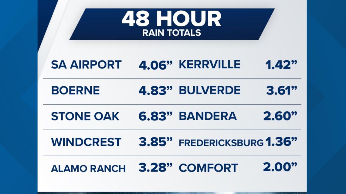
Rainfall totals for Tuesday and Wednesday were high as 8 inches in some areas of San Antonio and surrounding communities. Take a look at the rainfall totals below:

Thursday could bring more severe weather, but chances are lower.
A thunderous end to Memorial Day
After a stretch of above-average, late-May temperatures baked the San Antonio region to start the holiday weekend, boomed thunderstorms arrived Monday night. Thunder rang loudly in the Alamo City throughout the night and much-needed rain drenched neighborhoods in a parched city.
The worst of that overnight weather had cleared out by 3 a.m., with final showers just before sunrise.
The National Weather Service says some parts of far west Bexar County and northwest San Antonio saw upwards of 3 inches of rain. Some of those same neighborhoods also saw dangerously large hail.
A Tornado Watch issued for San Antonio and surrounding counties also expired with no apparent twisters forming in the Alamo City.
But CPS Energy crews worked through the night to restore power to thousands of impacted homes and businesses amid the consistent lightning. At one point early Tuesday , more than 12,000 customers were without power—a high-water mark during the storms that arrived as Memorial Day was ending. Click here to see the Outage Map.
The dangerous storms dropped into San Antonio from the north around 8:15 p.m., starting with frequent lightning and escalating to thunder and isolated showers.
Afternoon highs this week, meanwhile, will slowly normalize back to the upper 80s, which historically is where the Alamo City should see the mercury stopping in May.
The Alamo City, which the U.S. Drought Monitor says been in Exceptional Drought status since mid-March, is sorely in need of the precipitation; we’ve received just 6.11 inches of rain so far this year, about half what the city usually receives by now.
Day-by-day breakdown
Wednesday: Low 72, high 86. A more seasonable afternoon means the heat danger finally dies away after days of above-average temperatures. But Hump Day brings another 40% chance of rain.
Thursday: Low 72, high 88. More seasonable afternoons, more possible showers at 40%.
Friday: Low 73, high 86. Rain chances narrow to 20% amid partly sunny skies.
This is a developing weather event. Refresh the page for the latest updates.