The National Weather Service warns of a moderate risk of isolated flooding.
SAN ANTONIO — As search and recovery efforts continue following the deadly Fourth of July floods, there is a chance for “localized flooding” in certain areas west and southwest of San Antonio.
The National Weather Service has issued Flash Flood Warnings for the following counties:
- Kinney County, Knippa, Maverick, Normandy, Quemado, Sabinal, Spofford, Utopia and Uvalde Counties until 1:00 p.m.
- Bandera, Concan, Kerr, Leakey, Real & Uvalde counties until 1:30 p.m.
In a Facebook post, the Kerr County Sheriff’s Office urged volunteers to get to higher ground as new storms arrived early Monday afternoon:
“Due to the incoming threatening weather, all volunteers should vacate the river area, and MOVE TO HIGHER GROUND for their safety. Only teams working under the direction of Kerr County Emergency Operations Center Unified Command are permitted in the response zone.”
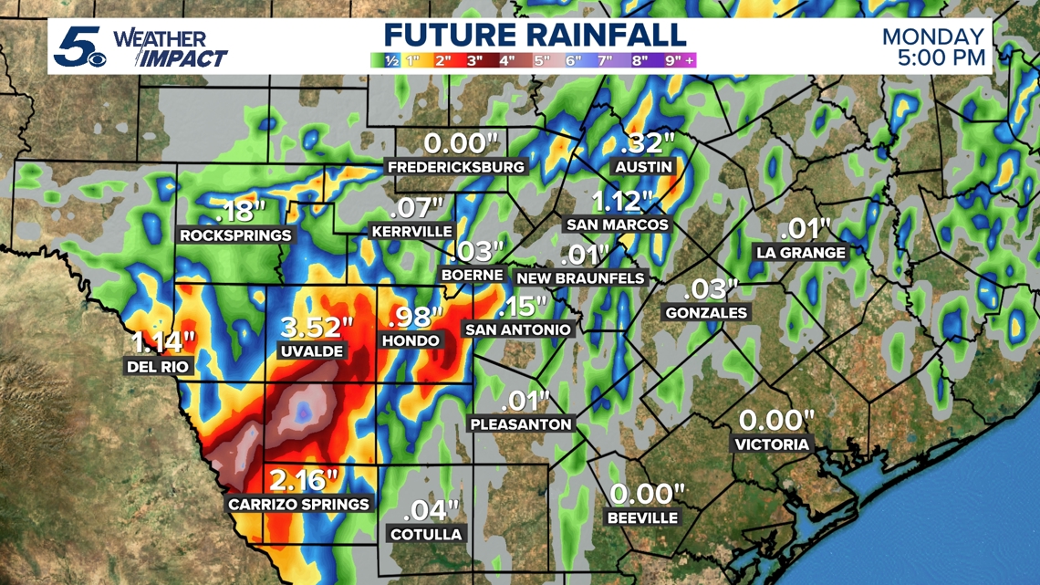
The National Weather Service says we’re still seeing very heavy rainfall across the Rio Grande/Southern Edwards Plateau with rates of 1-3 inches per hour based on radar estimates. Continue to avoid low water crossings and stay away from flooded areas. Remember turn around don’t drown.
The National Weather Service says heavy rains continue to affect the Rio Grande and southern Edwards Plateau areas. Rain rates are running from 4 to 6 inches per hour based on radar estimates. This is a dangerous situation. Flooding likely. Stay away from flooded areas.
A dangerous situation is occurring across northern Uvalde, eastern Real, western Bandera, and southwest Kerr Counties. 2 to 4.78 inches of rain have fallen the past 3 to 4 hours. More heavy rain is on the way. Flooding is already happening.
There is potential for heavy thunderstorms west of I-35 including Sunday night into Monday morning, which means there is a moderate risk of isolated flooding. Scattered showers are expected to continue Monday morning.
A Flood Watch for Bexar County, Medina County and the Hill Country has been extended until 9 a.m. Monday morning.
Temps over the next several days will continue to be below average to average in the low to mid 90’s, due to soil moisture levels.
Past Monday morning there is a 20% chance of an afternoon thundershower Monday afternoon and a 10% chance Tuesday afternoon.
Next week highs should be in the mid 90s.
Saharan dust should make a comeback for July 16 and July 17.

The NWS says you should take these three steps to stay safe during a flood:
- Get to higher ground and out of areas subject to flooding
- Don’t drive or walk into flooded areas as it only takes six inches of water to know someone off their feet
- Stay informed by monitoring local radar, television, weather radio, internet or social media for updates
This is a developing weather event. Refresh the page for the latest updates.