Here’s what to expect over the next few days in San Antonio as shopping and holiday seasons continue.
SAN ANTONIO — The Christmas season gets fully underway Friday in downtown San Antonio, with the Ford Holiday River Parade, Travis Park tree lighting and return of the River Walk lights ushering in the happiest time of the year.
The switch will be flipped on the H-E-B Christmas Tree around 6:20 p.m., and the Ford Holiday River Parade will be getting underway at around the same time.
But will the overhead clouds open up on families flocking to the heart of the city, and should you bring a jacket?
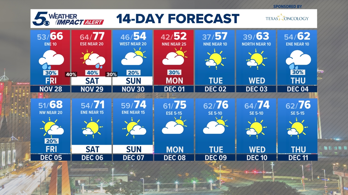
As far as precipitation, we’re only expecting light rain and patchy drizzle in the Alamo City on Friday evening, and cloud cover will most likely prevent the mercury from dipping back into the 50s.
We’re peaking in the mid-60s during the afternoon hours, with showers possible between 9 p.m. and 3 a.m. Saturday, according to the National Weather Service. Expect southeasterly winds of 10 to 15 mph, with occasional gusts as strong as 25 mph.
Here’s the hour-by-hour forecast for Friday evening:
4 p.m.: 63 degrees, 13% chance of rain, 10 mph winds
5 p.m.: 63 degrees, 24% chance of rain, 11 mph winds
6 p.m.: 63 degrees, 37% chance of rain, 10 mph winds
7 p.m.: 62 degrees, 36% chance of rain, 9 mph winds
8 p.m.: 63 degrees, 33% chance of rain, 11 mph winds
9 p.m.: 63 degrees, 34% chance of rain, 11 mph winds
10 p.m.: 63 degrees, 48% chance of rain, 11 mph winds
11 p.m.: 63 degrees, 47% chance of rain, 10 mph winds
Midnight: 63 degrees, 52% chance of rain, 9 mph winds
1 a.m.: 63 degrees, 57% chance of rain, 9 mph winds
2 a.m.: 63 degrees, 66% chance of rain, 7 mph winds
3 a.m.: 63 degrees, 44% chance of rain, 7 mph winds
\>>CLICK HERE for live radar
Looking ahead
Saturday will see much warmer temperatures as the Alamo City warms up into the 70s before arctic air sends the mercury plunging into the 40s Sunday evening.
A few storms will also start forming to the east of Interstate 35 late Saturday night. We could get some action in San Antonio proper, but the coverage is looking better east down I-10, closer to Houston.
Still, Saturday night will bring a marginal (Level 1 out of 5) risk for isolated severe storms in the eastern edge of Bexar County and counties heading out from that direction. Some isolated areas could see strong winds and even large hail as the cold front pushes through San Antonio. Areas east of the city could see up to an inch of rain.


Rain chances continue through Monday before the sunshine returns Tuesday, as well as some of our coldest morning temperatures of the season.


