San Antonio released a report analyzing the deadly June flood, found to be “consistent with a 25-year rainfall event.”
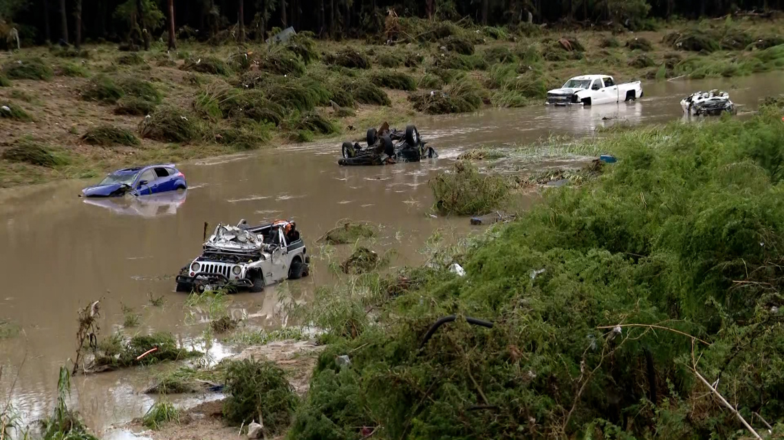
SAN ANTONIO — Nearly five months after 13 people died in a nighttime flood on the northeast side, the City of San Antonio has released a 138-page analysis of the deadly event.
The report, by independent engineering firm Kleinfelder, looked at data like rainfall totals in the area, historical records, engineering data and witness marks left behind by the raging waters.
The promise city leaders announced after the June 12 flood is a way forward, they said, to help save lives in the future. Bexar County leaders have already taken steps, allocating money through the new budget to implement a NextGen Flood Warning System, allowing the county to be more proactive in life-threatening rain events to come.
The report released Thursday focuses on the TxDOT access road that goes westbound adjacent to Loop 410 at the Beitel Creek crossing. That’s where 11 people were swept to their deaths when rushing water in the early morning darkness forced vehicles off the road and into Beitel Creek.
The report details how this section of roadway, built in the 1970s, is what they call a “sag”—a low spot that should be treated like a low-water crossing.
“There were no identifiable TxDOT requirements at the time that would have required accommodation for flooding from Beitel Creek,” Kleinfelder found. “Drainage right-of-way and easements along Beitel Creek immediately north of the Loop 410 (West frontage road) sag point lack clear ownership and therefore maintenance responsibility, which seemingly remains with the landowner.”
Since TxDOT owns the road, the summary of the report recommends collaborating with the state entity to:
- Install more gauges and warning signs with flashing lights that would allow for detours. Those improvements, the report says, should allow for safer options and keep vehicles from driving into danger.
- Plan for similar events, which the report estimated was “consistent with a 25-year rainfall event.” The report recommends consideration of the frequency of flooding, depth and velocity of water.
- Add more gauges in the watershed to provide real time warnings, and include City Public Works and the fire and police departments in emergency protocols.
- Improve the way the public is warned of danger by relocating gauges to improve early detection, especially at Thousand Oaks and the Loop 410 West access road, where so many people were lost.
- Work to develop comprehensive communication networks that takes advantage of mobile applications and reverse 911 systems for real-time public alerts.
- Clarify a plan for vegetation management in the heavily wooded areas adjacent to the area. Systems need to be developed with private property owners so that land will be maintained in a way that allows the water to flow freely.
The report presented to City Council on Thursday was a briefing only; no action was taken. The planning and the money will have to come later.
We have reached out to TxDOT for comment on the study, since they control much of the territory involved. Here is what they said:
“TxDOT continues to collaborate with the county, city and SARA in regard to the Perrin Creek flood event this past summer. Recommendations received from studies conducted by local partners will be reviewed, considered and evaluated for possible implementation in the future.
“It’s important to emphasize that this was a historic event, bringing an extraordinary amount of rainfall in a very short period, overwhelming natural waterways and drainage systems across the region. Safety remains our top priority, and the area is routinely inspected to ensure safety signage is properly placed and visible. TxDOT remains committed to working with local partners to ensure that infrastructure planning continues to prioritize public safety.”