Another stretch of spring-like temperatures rounded out the month of February, but changes are set to blow into South Central Texas on Thursday with a cold front.
It won’t be for everyone, but some storm activity is slated to accompany the front as it pushes through the area Thursday evening. A few storms could potentially become strong/briefly severe.
Here’s what we’ll be monitoring over the next 36 hours:
Wednesday Night
-
After another unseasonably warm day with highs in the upper 80s, a few showers/a stray storm may try to pop up Wednesday night
-
Overall coverage should be pretty low, but warm and muggy conditions will still be in place for all
Thursday
-
Additional areas of fog, drizzle, and mist will be possible Thursday morning with lows in the muggy 60s, followed by highs in the 80s on Thursday afternoon
-
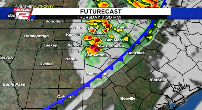
The cold front is currently expected to push into our western counties after 3 p.m., arrive in the San Antonio area between 6-8 p.m., and then exit out of our eastern counties by 9-10 p.m.
-
Some showers and storms are expected to accompany the front before downright WINDY conditions take over Thursday night and Friday. More on that below:
Small Severe Weather Potential
-
While the higher threat of severe weather is off to our north and east with this weather setup, an isolated strong storm or two can’t be ruled out in South Central Texas
-
As of Wednesday morning, the Storm Prediction Center has placed the Hill Country, most of Bexar County, and areas along and east of Interstate-37 in a low-end 1/5 risk for that severe storm potential
-
Gusty, strong winds will be the main concern should a strong storm require a bit of extra attention, mainly between 4-9 p.m.
WINDY Conditions Arrive Behind the Front
-
After the front passes through, a gusty northwest wind kicks up in its wake. Winds gusts upwards of 45-50 mph are possible Thursday night and into Friday morning
-
Before the front arrives on Thursday, it wouldn’t hurt to secure any loose items and make sure that trash cans are brought in close to the house
-
These windy conditions are expected to continue through at least the first half of the day on Friday, before settling down a bit Friday night
-
Dry air will also punch into South Central Texas behind the front, so elevated fire danger conditions will be in place throughout the day on Friday. Plan to avoid outdoor burning
Temperatures into the Weekend
-
After a stretch of 80 degree days this week, Thursday’s cold front looks to make for a few chilly mornings followed by comfortable afternoons into the upcoming weekend
-
Jackets will briefly be needed by Friday and Saturday mornings with temperatures in the 40s, but afternoon highs should be able to climb into the 70s each day with plenty of sunshine
-
Another warming trend does look to be just around the corner, with highs approaching 80° again by Sunday
Weather-On-The-Go
Your Weather Authority will keep you updated as this storm chance and cold front approach the area. We’ll send notifications right to your phones, and you can see the forecast and check the radar by downloading the KSAT Weather Authority App for Apple or Android. 📱 Be sure to allow notifications for updates, including livestreams from KSAT meteorologists.