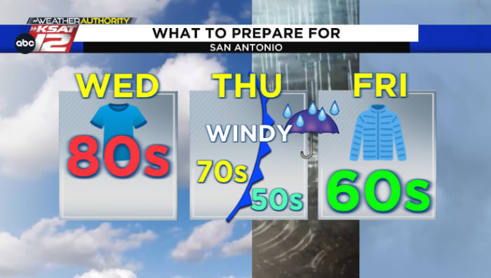
After a warmer than average first half of the week, a cold front will push through South Central Texas on Thursday, sending rain chances and cooler air back into the forecast.
Here’s the latest:
Key Points
-
A cold front arrives in South Central Texas on Thursday, pushing through the Hill Country in the morning, then moving into the San Antonio area around midday
-
After reaching the mid-70s around lunchtime, temperatures will fall into the 60s in the afternoon followed by the 50s Thursday night. Wind gusts up to 25-30 mph will also kick on after the front passes by
-
Rain chances increase along and behind the front, with scattered-to-widespread activity expected by late Thursday afternoon, evening and overnight
-
Lingering showers will be possible for the Friday morning drive before tapering off through the remainder of the day. Cloud cover is slated to hold afternoon temperatures to near 60 degrees
-
A cooler forecast returns for the weekend with highs in the low 60s and lows in the 50s. Most will catch a break from the rain Saturday before another round tries to work in Sunday and into Monday
Cold Front Arrival Times Thursday
-
Hill Country: 8 a.m. – 11 a.m.
-
San Antonio Area: 11 a.m. – 1 p.m.
-
Coastal Plains: 1 p.m. – 4 p.m.
The cold front will start to push through the Hill Country around or just after the morning commute. As it continues to slide southbound, the boundary will then move through the San Antonio area around lunchtime and push through the Coastal Plains through the early afternoon.
Temperatures & Rain Chances
After starting off in the muggy upper 60s Thursday morning with some patchy drizzle, temperatures will manage to climb into the mid-70s by midday in San Antonio. After the front passes by, thermometers will fall through the 60s Thursday afternoon and eventually settle into the 50s by Thursday night. Expect gusty north winds to also kick up as the front passes by, with wind gusts upwards of 25-30 mph expected by late Thursday afternoon and evening.
Rain chances will also increase as the front passes through the area, and even more so behind it. A broken line of rain is forecasted to accompany the boundary’s arrival, followed by scattered-to-widespread rain into the Thursday afternoon, evening, and overnight timeframe. Scattered, lingering showers are expected around the Friday morning drive, but the remaining activity should taper off through the remainder of the day with cloud cover holding afternoon temperatures to about 60 degrees and wind gusts up to 25 mph.
Weekend Forecast
Most should catch a break from the rain Friday night and Saturday, minus an isolated shower or two. While not as cold as the front that arrived in time for Halloween last week, sweater weather returns this weekend with lows in the 50s followed by highs in the low 60s Saturday and Sunday.
Another round of rain will try to work into parts of South Central Texas on Sunday and into Monday. Still some details to fine-tune with this second round, but it’s possible that up to 1-2 inches of rain could fall in spots by the time all is said and done, so check back for updates in the coming days!
Read more from the meteorologists on the Whatever the Weather page
Download KSAT’s weather app for customized, accurate forecasts in San Antonio, South Texas or wherever you are
Find the latest forecasts, radar and alerts on the KSAT Weather Authority page
Original News Source Link
Need digital marketing for your business? Check out KingdomX Digital Marketing San Antonio!