Stay updated with the KENS 5 Weather Team on this severe weather development and how it impacts you.
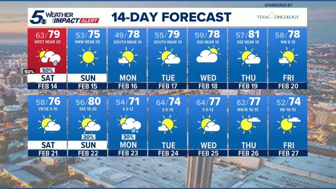
BEXAR COUNTY, Texas — IMPACT DAYS: Saturday afternoon, Feb. 14, 2026
Reason: Possibility of severe storms producing hail and damaging winds
The breakdown
A Pacific system will deliver scattered showers beginning overnight Friday heading into Saturday morning as the possibility of a soggy Valentine’s Day in San Antonio gains traction.
As the Pacific front swings through between 3 p.m. and 7 p.m., a line of stronger storms is expected to develop. The National Weather Service has placed the San Antonio metro and Hill Country at a level 1 out of 5 risk for severe weather later on Saturday, with San Antonio most vulnerable from 5 p.m. to 9 p.m.
The primary threats posed by these storms: hail and damaging winds. Gusty, westerly winds will move in Saturday night before strong north-northwesterly winds blow through on a sunny and mild Sunday.
As of Friday evening, these are the likelihoods that your community will see rain on Saturday:
- Fredericksburg: 85% chance of rain
- Gonzales: 85%
- San Antonio: 85%
- Rocksprings: 75%
- Kerrville: 80%
- New Braunfels: 80%
- San Marcos: 80%
- Uvalde: 65%
- Del Rio: 50%
- Eagle Pass: 30%
Most San Antonio-area communities will see afternoon highs reaching the mid-70s on Saturday, with Del Rio and Eagle Pass are expected to poke into the low-80s. Monday morning will see lows in the high-40s returning across the region.
Looking ahead
Sunday and the week beyond will be much drier, warmer and (mostly) sunnier compared to Saturday’s conditions. San Antonio could return to the 80s as soon as Thursday amid partly cloudy skies, with the next rain chances not expected until Sunday, Feb. 22.

This is a developing weather event. Refresh the page for the latest updates.