SAN ANTONIO — Weather Impact Alert Days: Wednesday, Feb. 19, Thursday, Feb. 20, Friday, Feb. 21 and Saturday, Feb. 22
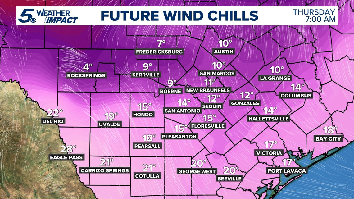
Reason: Cold temps with wind chills as low as 15 degrees in the city and single-digits across the Hill Country. There’s a chance for drizzle Friday with temperatures in the 30s.
What we’re expecting
Winter is not done with us just yet!
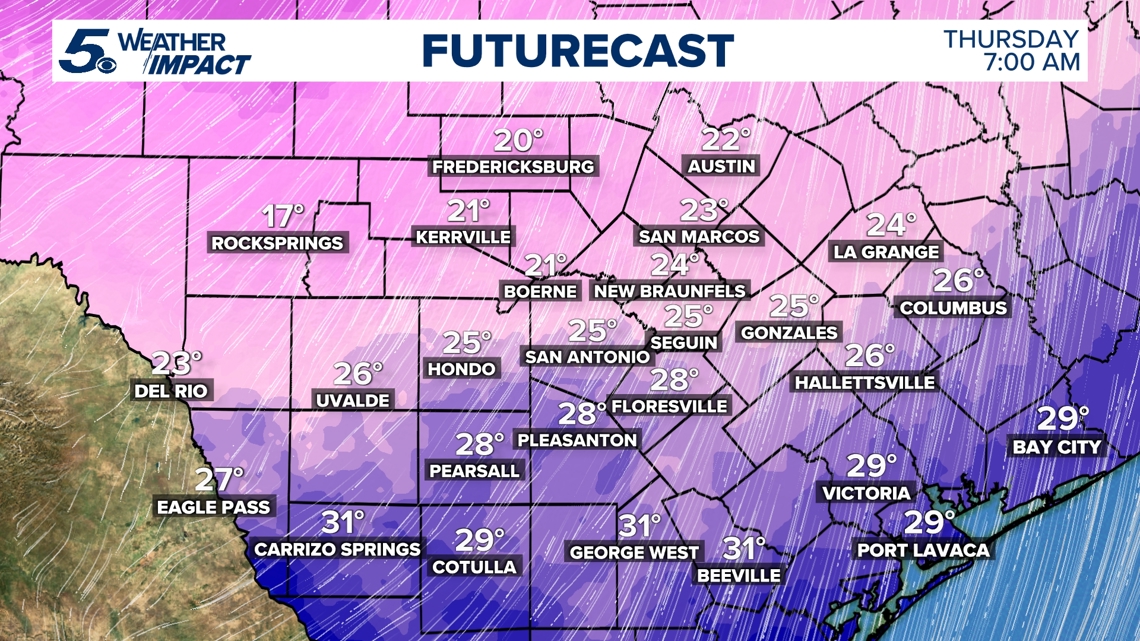
Cold air is now in place across South Central Texas. The main change in the forecast is that an Extreme Cold Warning is now in effect for the southern Edwards Plateau, Hill Country, and I-35 corridor through noon Thursday. A Cold Weather Advisory is now in effect for the Coastal Plains and Rio Grande Plains through noon Thursday.
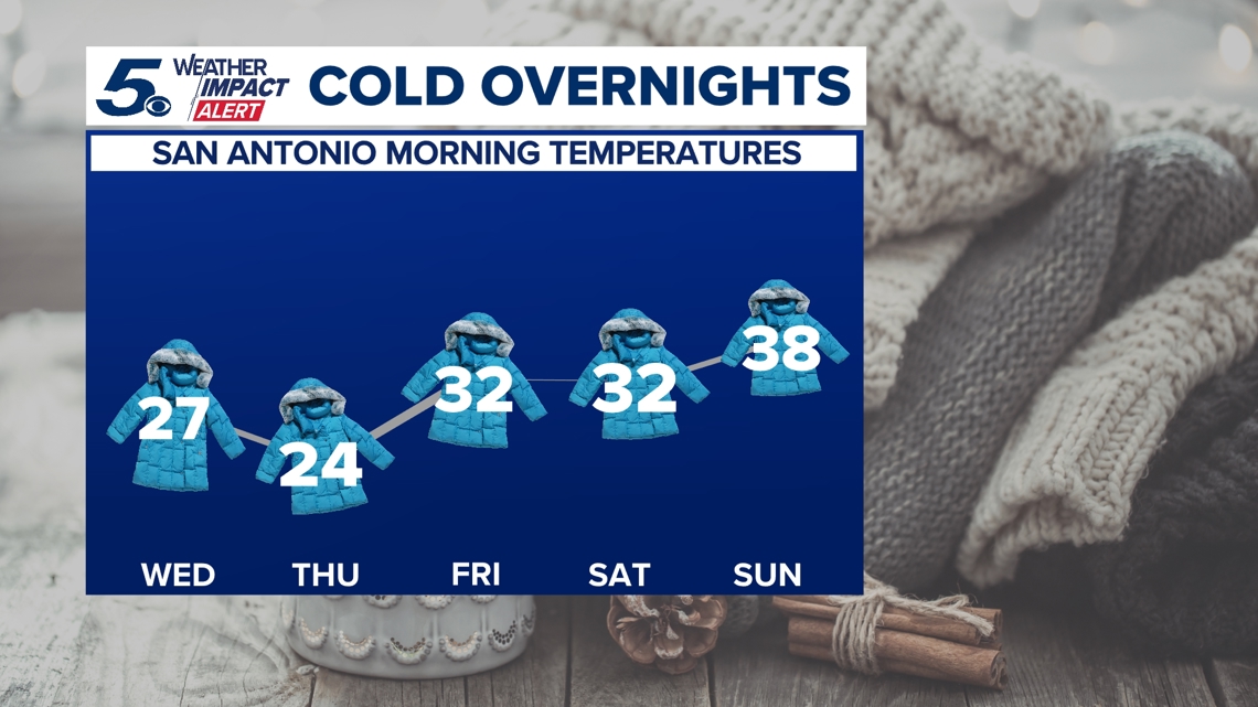
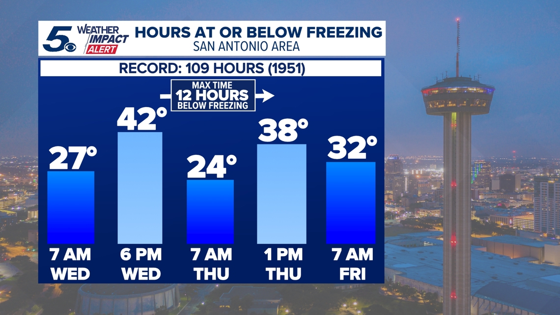
The National Weather Service says it’ll bring below-normal temperatures that will stick around through Saturday, including morning lows of 27 and 24 degrees in San Antonio on Wednesday and Thursday, respectively.
The average low for this time of year in San Antonio is 46, per NWS data.

Wednesday’s daytime highs will be about 30 degrees colder than the day prior. Current rain chances look very low and the threat of icing also remains fairly low.
In anticipation of the bitter cold, the NWS has issued an Extreme Cold Warning for the Hill Country lasting from midnight Tuesday through noon on Wednesday.
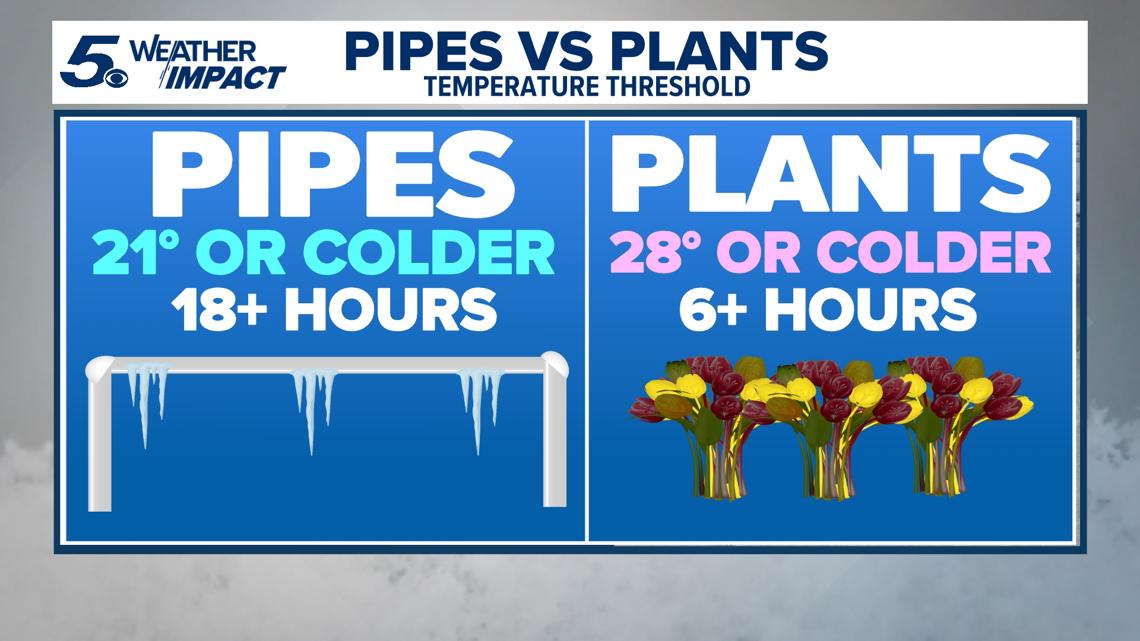
This winter storm will also be colder for the Hill Country, so prepare to wrap your home’s pipes for this week’s weather. When temperatures drop, always remember: people, pets, plants and pipes!
That is, check on your vulnerable neighbors; bring pets inside overnight to shelter them from the bitter cold; and protect your plants and pipes so they aren’t damaged.

Day-by-day breakdown
Wednesday: Low 27, high 44. The day will start off about 20 degrees colder than normal in San Antonio as the latest freeze arrives in South Texas. Wind gusts topping out at 16 mph will make it feel even colder.
Thursday: Low 24, high 43. Another day, another day of morning lows in the 20s and highs barely reaching the mid-40s. Make sure to bundle up: Wind gusts of 10 mph throughout the day will make it feel like it’s in the teens. If you live in the Hill Country, prepare for it to feel like single-digits.


Friday: Low 32, high 37. Temperatures warm up ever so slightly, but are still technically expected to be at freezing levels on the last morning of the work week. There’s also a 10% chance of precipitation that could make roads slick. Wind gusts top out at 11 mph. This will also be the coldest afternoon of this cold snap, with the mercury not expecting to reach 40 degrees.

Saturday: Low 32, high 47. The shower chances rise to 30% in San Antonio, but so do the afternoon highs to near 50 degrees. The average historical high for this day in the Alamo City is 69.
Sunday: Low 38, high 68. No rain chances, and the wind also dies down as the afternoon sees a huge warm-up compared to Saturday afternoon.
Monday: Low 46, high 76.
State preparations
Meanwhile, the state’s power grid operator ERCOT on Monday issued a Weather Watch for this week, putting it into effect from Wednesday through Friday. ERCOT said it’s expecting grid conditions to be normal even with the colder temperatures, adding there’s expected to be a higher electrical demand and potential for lower reserves in Texas.
Governor Greg Abbott also expressed confidence the power grid will be able to handle what could be some of the coldest conditions ever experienced in parts of Texas.
This is a developing weather event. Refresh the page for the latest updates.