Stay updated with the KENS 5 Weather Team on this severe weather development and how it impacts you.
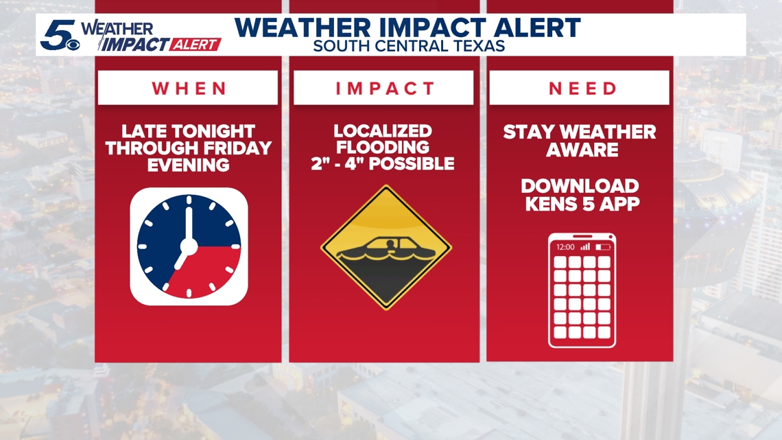
BEXAR COUNTY, Texas — IMPACT DAYS: Friday, May 1
Reason: Heavy rain and localized flooding.
Active weather alerts
- Severe Thunderstorm Warning in effect until 3 a.m. for northeastern Lavaca County; quarter-sized hail and 60 mph wind gusts possible.
- Severe Thunderstorm Warning in effect until 3:15 a.m. for southwestern Frio and southern Atascosa counties; quarter-sized hail and 60 mph wind gusts possible.
- Severe Thunderstorm Warning in effect until 3:30 a.m. for southwestern DeWitt, northeastern Karnes and south-central Gonzales counties; quarter-sized hail and 60 mph wind gusts possible.
- Flood Advisory in effect until 8 a.m. Friday for Bandera, Bexar, Caldwell, Comal, Gonzales, Guadalupe, Hays, Kendall and Medina counties. Urban and small stream flooding caused by excessive rainfall is expected.
- Flood Watch in effect until 9 p.m. Friday for Bandera, Bexar, Comal, Edwards, Gonzales, Guadalupe, Kendall, Kerr, Kinney, Medina, Real, Uvalde, Val Verde and Wilson counties.
The breakdown
A strong spring cold front has generated an active weather pattern that will continue through Friday.
With the Flood Watch now in effect, multiple waves of heavy rain are now expected to drench the area through Friday night.
Bexar County saw showers and a few thunderstorms Thursday night, with coverage increasing overnight and into Friday morning. Then, at least two or three more waves of heavy rain are expected to move across the area Friday.
Large hail and lightning are the biggest weather threats if any storms materialize. Drivers are urged not to ignore barricades and to find detours if low-lying roadways are flooded.
Two to four inches of widespread rain accumulation are possible, with isolated pockets of five-plus inches of rain also in the cards. We should see the rain clear to the east of San Antonio by 8 p.m. Friday.
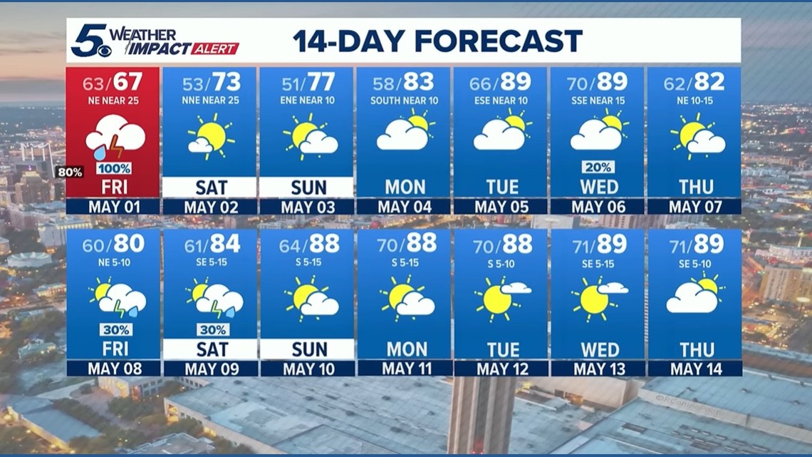
The weekend will bring much cooler and sunnier conditions, along with some wind. If you’re in the Hill Country, you might even see the mercury dip below 50 degrees.
Here is a sample of expected Saturday morning lows across the area:
- Rocksprings: 46 degrees
- Fredericksburg: 47
- Llano: 47
- Kerrville: 48
- Uvalde: 50
- Gonzales: 52
- San Marcos: 51
- New Braunfels: 52
- San Antonio: 53
- Del Rio: 54
- Eagle Pass: 55
Looking ahead
The rain will clear out in time for the rescheduled Siclovia on Sunday. The average high temperature for May in San Antonio is 87 degrees, so we’ll be kicking the month off with unseasonably cool conditions this weekend before the mercury rises back to more typical temperatures.
The next chance of rain arrives midweek.
This is a developing weather event. Refresh the page for the latest updates.